17. Oost 1, Maps & Marvels: De Seynbrief
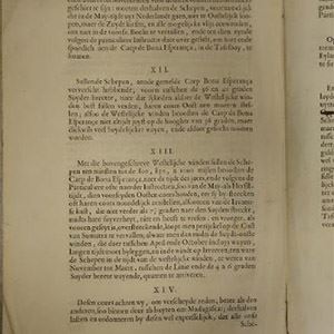
These instructions are one of the most important documents in the history of Australia. They led, indirectly, to the discovery of the continent by Dutch captains working for the East India Company in the seventeenth century. These captains succeeded in mapping out the entire west coast and parts of the south coast of Australia for the first time. On their way to Asia, East Indiamen had previously sailed from South Africa along the coasts of Africa and India, towards Java in Indonesia. The instructions in this document state that skippers should no longer head northwards once they had passed southern Africa, but must continue to sail 4,000 nautical miles eastwards, straight across the Indian Ocean. Only then should the ships start heading north. This allowed them benefit from the westerly winds, and the new nautical route saved expeditions to the East at least six months’ travelling time each way. But as measuring longitude – your east/west position – was still highly inaccurate at the time, many vessels sailed too far to the east. This led, unintentionally, to the continent of Australia being added to the Europeans’ map of the world for the first time.


The National Maritime Museum
Het Scheepvaartmuseum (The National Maritime Museum) shows the strong connection between the maritime world and society as a whole, and more specifically the impact of this on the lives of many individuals. The collection of The National Maritime Museum is one of the largest and most notable maritime collections in the world with approximately 400,000 objects, including paintings, models of ships, navigation instruments, and maps of the world. Discover 500 years of Dutch Maritime history as well as its strong links to today’s society and the society of the future.
- Kattenburgerplein 1
- Amsterdam Netherlands
- (020) 52 32 222
- www.hetscheepvaartmuseum.nl
