15. Oost 1, Maps & Marvels
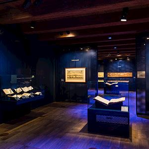
Until the fifteenth century, Europe’s picture of the world was determined by maps that were centuries old and in which large parts of the world were missing. Sea voyages produced new information and, little by little, all the pieces of the puzzle that was the Earth’s surface fell into place. As the Dutch built up their international trade network, they increasingly contributed more pieces to the puzzle. The mapmakers of Amsterdam acquired an international reputation. When projecting the curved surface of the Earth onto a flat plane, choices have to be made. Which continent should the map of the world be centred on? What goes at the top and what goes at the bottom? What appears to the left and what to the right? Amsterdam mapmakers used the projection invented by the Flemish cartographer Gerard Mercator, in which Europe is relatively large and positioned centrally on the map. Even today, the Mercator projection is the most common. The map of the world hanging on the wall here is an example of what is known as the Gall-Peters projection, developed in order to represent the land areas of the various continents in correct proportion. It is immediately clear that this map creates a very different image of the world. This exhibition uses maps, coastal views, globes and souvenirs to show how the European view of the world was gradually expanded, through Dutch voyaging around the world.


The National Maritime Museum
Het Scheepvaartmuseum (The National Maritime Museum) shows the strong connection between the maritime world and society as a whole, and more specifically the impact of this on the lives of many individuals. The collection of The National Maritime Museum is one of the largest and most notable maritime collections in the world with approximately 400,000 objects, including paintings, models of ships, navigation instruments, and maps of the world. Discover 500 years of Dutch Maritime history as well as its strong links to today’s society and the society of the future.
- Kattenburgerplein 1
- Amsterdam Netherlands
- (020) 52 32 222
- www.hetscheepvaartmuseum.nl
